Research
My research has mainly been in two fields: orographic flow and predictability of the atmosphere.
Orographic flow
Mountains have large impact on weather and climate both locally and on a largers scale. The Föhn wind in the Alps and the Chinook in the Rocky mountains are caused by the impact of the orography on the atmospheric flow.
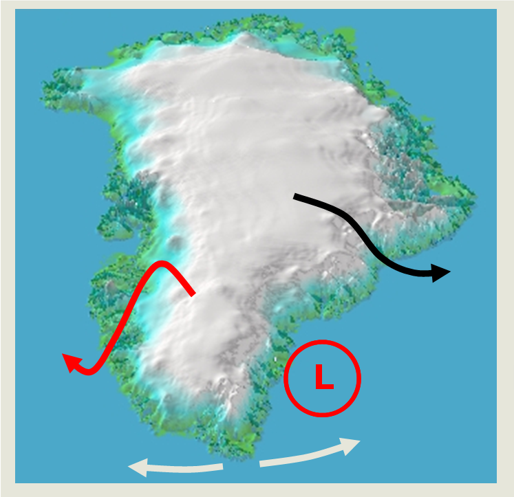
Greenland is a large mountain, it extends from about 60N far north...XX 
Greenland is located just north of the North Atlantic storm tracks, the track frequently used by low moving from the east coast of North America to the northeast over the North Atlantic. In the vicinity of Iceland, just east of southern Greenland, there is a climatic low pressure in the winter time termed the Icelandic low. This is due to cyclones moving through the area and cyclones developing between Greenland and Iceland. It seems reasonable to assume that Greenland has some impact on the location of this low pressure, along with sea surface temperature gradients.
I've studied the impact of Greenland on the atmospheric flow using different approaches.
- I've studied simple flow over simple mountain of the same size as Greenland, looking at the impact of the Coriolis force on the flow (Petersen et al. 2003; 2005).
- I've also used a general circulation model to look at how Greenland can impact the atmospheric flow on a longer time scale (Petersen et al. 2004).
- Currently I'm involved in the Greenland flow distortion experiment (GFDex), investigating more local weather phenomena in Greenland's vicinity that can have large impact on the underlying ocean through fluxes of heat and moisture. These are tip jets, eminating from the souther tip of Greenland Cape Farewell and barrier winds, strong low level wind jets along the southeastern coast of Greenland. Other weather phenomena in the region that are of interests and can have impact on the ocean are mesoscale cyclones and polarlows. The GFDex field campaign took place in February and March 2007. We based ourselves in Keflavík, Iceland and flew in the vicinity of Iceland and southeastern Greenland observing the atmosphere. Targeting, see below, was also a vital part of the campaign.
Predictability of the atmosphere
There are inevitable uncertainties in the prediction of weather and climate. The cause of these uncertainties can be divided into the following types: uncertainties in the initial state and model uncertainties, which include those due to poor representation of unresolved scales in the numerical model. Two almost identical initial states can therefore evolve in time to widely different states.

The figures on the right shows the finite time ensembles of the Lorenz (1963) systems. The upper figure shows that an ensemble where the ensemble members agree quite well with each other. If this was a prediction of rainfall one would say that the likelihood/risk of rainfall was very high. The lower right figure shows a wide spread in the ensemble and it is almost impossible to predict the time evolution. The lower left figure shows in-between-state. It is not possible to be certain what is going to happen, but it is possible to say something about the risk of e.g. rainfall.
This means that in order to get a better picture of the evolution of weather and climate, it is necessary to run the numerical models several times from slightly different initial conditions and slightly different model representations. The resulting forecast is not one value, for e.g. temperature, at each forecasting time, but a probability distribution function (pdf) from the ensemble. This pdf gives us information about the probability of a certain event and the forecast skill must improve on climatology or persistence to be meaningful. This method is called ensemble prediction and is used by e.g. ECMWF, the European Centre for Medium-range Weather Forecasts. So by forecasting predictability, we predict weather and climate risk. That is, we predict how likely a certain weather or climate is.
The numerical weather prediction (NWP) forecast system consist of several components
- Observations
- In-situ observations, such as synoptic observations and radiosondes
- Satellites
- Ground-based remote sensing, such as radar and lidar
- Commercial aircraft observations (AMDAR)
- Merchant ship observations (ASAP)
- Data assimilation
A first guess short-range forecast, the background forecast, is combined with observations to create an analysis - Numerical models, global and regional
- Ensemble forecast
The uncertainties in initial conditions and model formulation are explored.- Initial conditions: A lack of representativity and accuracy of observations and error in the background forecast
- Model formulation: Uncertainties in parametrisations and stochastic physics
- Users
Recently there have been major developments in weather prediction. These advances have come from developments in modelling and in making and utilising observations:
- Ensemble prediction and probability estimation
- Increasing model resolution
- Satellite observational capability
- Variational data assimilation
However, The inaccuracy in initial conditions and the uncertainties in model formulation still cause
- Significant failure in forecasts of high impact weather
- Inability to extend the range of skillful prediction sufficiently into week two of the forecast range
- Poor description of tropical influences on extratropical forecasts and vice versa
- Inadequate skill in predicting mesoscale weather such as precipitation
The forecast system described above has the users of the forecast as the last link. In the future the users will have more impact on the forecast system and the forecast system will be more interactive. That is, there will be more flow of information between the users, the forecast system and the observations. An example of such interaction is targeting.